
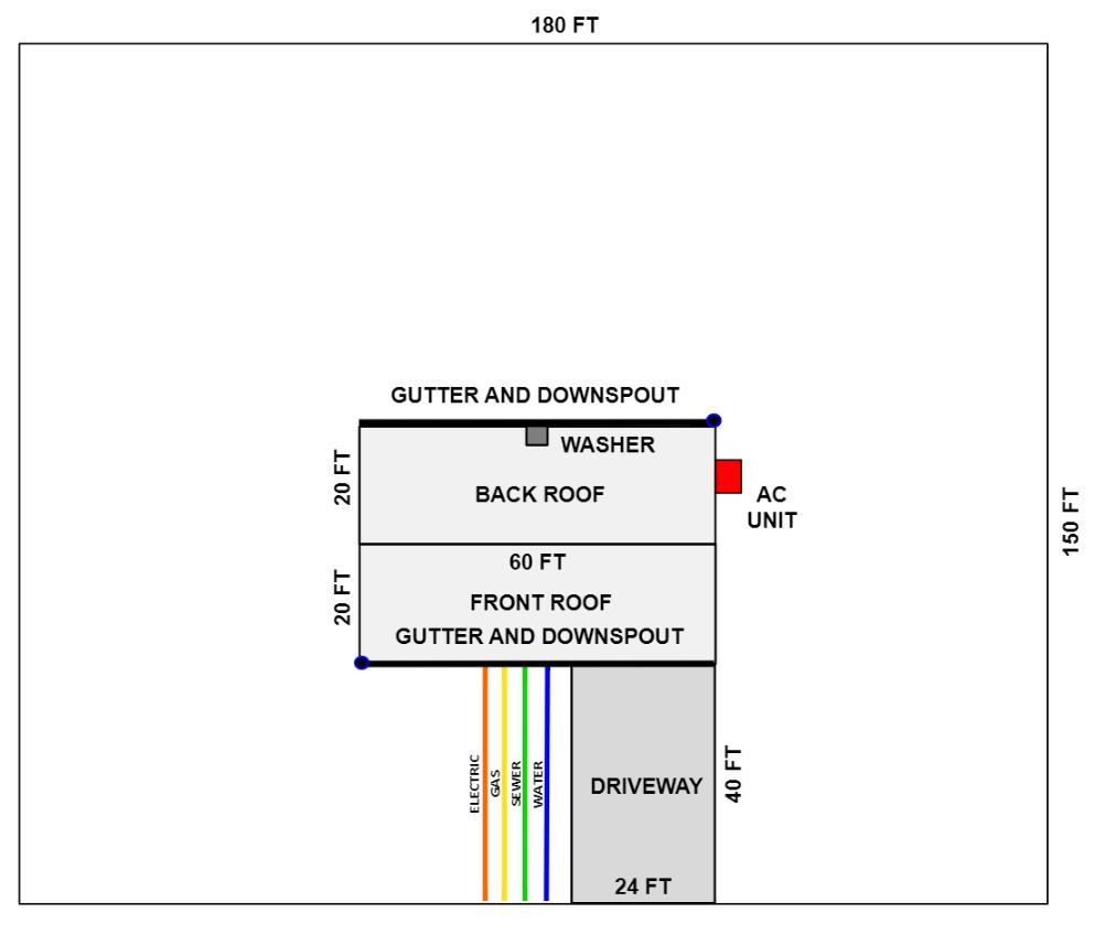
Understanding Site Conditions and Microclimates Click Here for PDF of Understanding Site Conditions and MicroclimatesWalk around your site. Take a close look at land slope, sun, shade, soil, signs of strong winds, patterns of water flow and other site characteristics. Imagine your site on freezing nights, in windstorms and when it is raining hard. Feel the difference on the sunny and shady sides of buildings. Microclimates are small, localized climatic conditions that may be warmer, colder, dryer, wetter, windier or calmer than other areas of a site. They are formed by patterns of sun, shade, wind, soil and water flow along with the natural and built landscape of hills, valleys, vegetation, buildings and paved surfaces. Microclimates are created when these features change airflow; increase or decrease day length or sunlight intensities; accumulate heat during the day which is released slowly at night and in other ways modify local temperature, light, wind and moisture. Soil conditions also affect microclimates. Trees have different sensitivities to temperature, rainfall, humidity, wind, day length and sunlight intensity—among other conditions. People can both harness and modify microclimates using tree placement, structure placement, irrigation, mulching, sun protection, frost protection and many other strategies. When choosing and placing trees, observe site conditions and microclimates and determine how to modify these to benefit trees and help trees benefit you. One way to help you visualize site conditions and select appropriate places to plant trees is to start with a site base map. This can be a simple sketch, or an aerial photo or site plan with written notes added. It is helpful to show property boundaries, roofs, driveways, vegetation, walls, and other physical features, along with which direction is north (south, east or west). You can use the site base map to understand and illustrate conditions at your site, including those discussed in the sections that follow. Always find out and mark where utility lines are located. Do not plant trees over buried utility lines or under overhead utility lines. Use extreme caution if you are digging near buried utility lines. Before you dig, Contact Arizona 811 (formerly known as Blue Stake) to mark buried utility lines between the street and utility meters on your property. To mark additional utilities line locations within your property, contact a private utility locating service. |
ADDITIONAL RESOURCES Mapping Simply “Google” your site address and a road map will typically appear. Select ‘satellite’ view on the road map to get an aerial photo of your site. Zoom in and out with the ‘+ and –” buttons. Or use more advanced mapping sites, such as the one listed below. https://www.google.com/earth/Utility line safety in Arizona https://www.tep.com/vegetation-management/ |

CAUTION: Never eat anything that is not properly identified. It is your responsibility to ensure that all fruits, nuts, seeds, pods and other edible products of trees and shrubs are correctly identified and safe to eat before eating them or serving them to others.
Copyright 2023
LEAF is under the fiduciary stewardship of the Arizona Community Tree Council, a 501(c)3 non-profit organization.
70 S Val Vista Drive, Suite A3-186, Gilbert, AZ 85296

EQUAL OPPORTUNITY
This website and other LEAF Network products shown here was prepared under the Diverse Urban Forest grant, WCG 14-501, administered by the Arizona Community Tree Council. Funds for this project were provided by the Urban and Community Forestry Financial Assistance Program administered through Arizona Department of Forestry and Fire Management – Urban and Community Forestry Program and the U.S. Department of Agriculture (USDA) Forest Service. In accordance with Federal law and USDA policy, this institution is prohibited from discriminating on the basis of race, color, national origin, sex, age, or disability (Not all prohibited basis applies to all programs). To file a complaint of discrimination, write USDA, director, Office of Civil Rights, Room 326-W, Whitten Building, 1400 Independence Avenue, SW, Washington, DC 20250-9410 or call (202) 720-5964 (voice and TDD). USDA is an equal opportunity provider and employer.